

 Back to All
Sponsored Content
Drought and flood tend to be thought of as separate stories, but for a growing number of regions across the world, they’re really one story with two chapters. The Pacific Northwest’s (PNW) 2026 Water Year offered a striking example, with record flooding, low snowpack, and persistent drought forcing water managers to shift quickly between competing priorities. Navigating these extremes requires forecasts that provide early warning of high flows while helping operators anticipate longer-term changes in water availability.
Drawing on our experience deploying HydroForecast, our machine learning-based hydrology model, throughout the 2026 Water Year, we share lessons on forecasting both extremes and how operators can use those insights to make more informed decisions.
One water year, multiple extremes
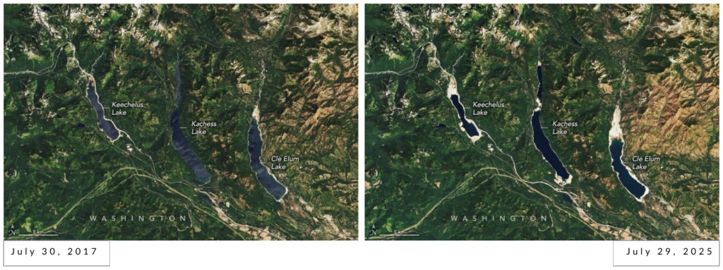
The PNW 2026 Water Year illustrates just how quickly water conditions can shift. In fall 2025, parts of Washington State were deep in drought (Figure 1a), forcing farmers to remove apple orchards and driving reservoirs to historically low levels. Just months later, a series of atmospheric rivers brought record flooding in December, followed by another round of heavy precipitation in March 2026 (Figure 1b). Yet despite the wet winter, low snowpack left the region facing a poor snowmelt season, and a warm, dry summer pushed much of the region back into drought (Figure 1c).
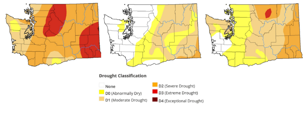
Figure 1 – U.S. Drought Monitor classifications throughout the 2026 Water Year. 1a (left) shows Washington State on October 7, 2025, 1b (middle) April 7, 2026, and 1c (right) August 11, 2026.
These rapid swings highlight a growing challenge for water managers: responding to immediate flood risks while planning for water shortages months ahead. Adding to that uncertainty, a potentially historic El Niño is currently developing in the Pacific (Figure 2). The NOAA Climate Prediction Center now estimates over an 83% chance of strong to very strong El Niño conditions between January and March 2027. El Niño typically brings warmer, drier winters to the PNW, often reducing snowpack and spring runoff. But with an event of this potential magnitude, historical patterns may offer limited guidance, making it even more important for operators to prepare for a range of possible conditions.
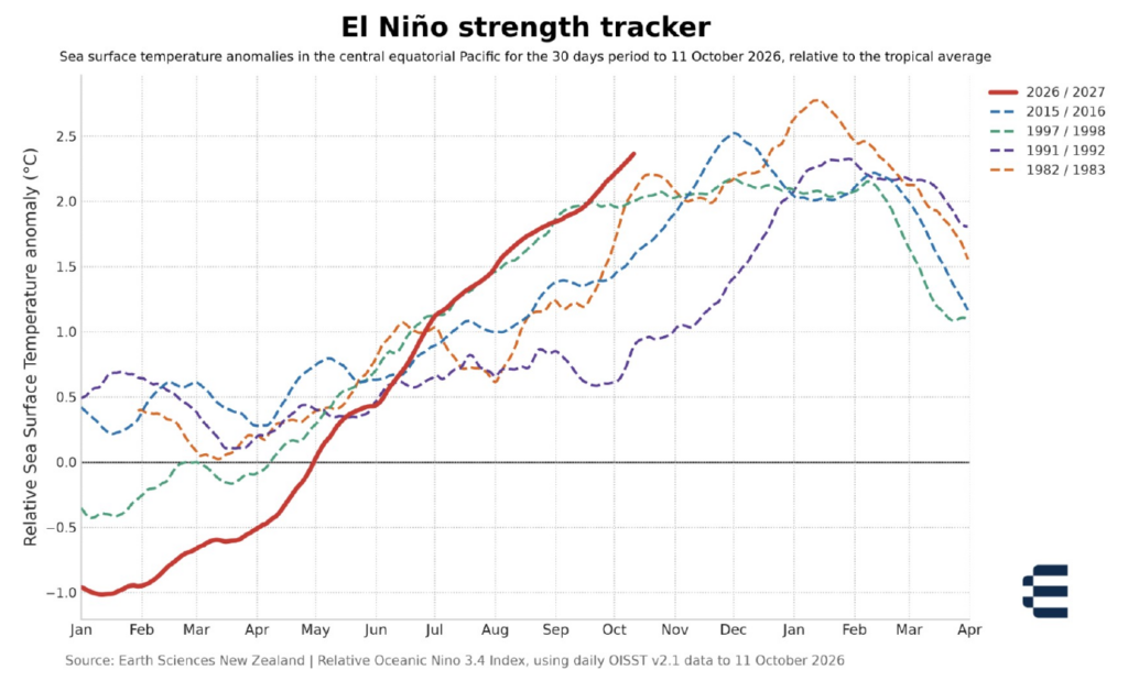
Figure 2 – Sea surface temperature anomaly in the central equatorial Pacific (Relative Oceanic Niño Index), 2026/27 vs. four of the strongest past El Niños, through October 13, 2026. As of mid-October, 2026/27 is warmer than the previous four were at this point in the year. Compiled by Earth Sciences New Zealand.
Forecasting floods: Early warning and managing uncertainty
During a flood event, a dam operator’s priorities can shift quickly. Hydropower generation and lake recreation goals take a back seat as dam safety and downstream flood risk become the immediate focus. This is where forecasting provides critical value: giving operators more time to prepare and helping them understand the range of possible outcomes before floodwaters arrive.
During the December 2025 atmospheric rivers (Figure 3), the HydroForecast team supported dozens of dams across the PNW with forecasts and analysis to inform flood response. At one dam in Washington, HydroForecast predicted peak flows nine days in advance, four days earlier than the Northwest River Forecast Center, with a peak flow estimate roughly 35% closer to what was observed. Operators used that lead time to balance two competing priorities: managing the initial surge of water while preserving reservoir capacity for the flooding still to come.
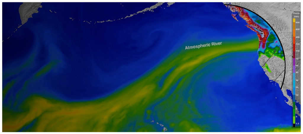
Figure 3 – Accumulated precipitation and atmospheric moisture from the December 2025 atmospheric rivers. Image credit: NASA
The preceding drought added another layer of complexity. Soils were extremely dry before the atmospheric rivers arrived, making it difficult to predict how much rainfall would soak into the ground versus flow into rivers and reservoirs. All hydrological models carry uncertainty from their inputs and underlying methods, but these unusual conditions made accounting for a range of outcomes especially important. HydroForecast uses techniques including transfer learning, multiple model inputs, and probabilistic modeling to learn from extreme conditions around the world and quantify that uncertainty.
At another Washington dam, the range of possible outcomes was especially wide (Figure 4). Cumulative precipitation forecasts varied from 4.8 to 7.8 inches across the basin, while predicted inflows spanned more than 100,000 cubic feet per second (cfs). At the low end, flows around 11,000 cfs would represent only a minor deviation from normal operations. At the high end, flows reaching 130,000 cfs would constitute a major flood event. HydroForecast’s mean prediction ultimately landed close to observed flows, but the value went beyond forecast accuracy. Operators had days to prepare for multiple scenarios and could refine their plans as the storm unfolded.
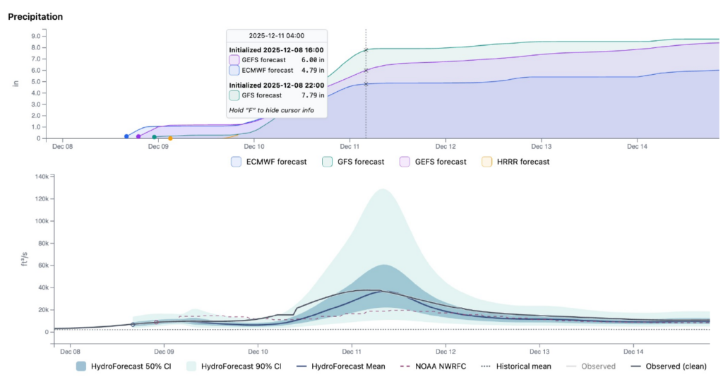
Figure 4 – Forecasted cumulative precipitation and HydroForecast predicted inflows at a dam in Washington before the December 2025 atmospheric rivers.
Forecasting drought: Low snowpack and elevated snow lines
While operators were managing high flows in December 2025 and March 2026, another challenge was emerging: how would these wet periods affect water availability in the months ahead? Would the precipitation replenish snowpack and improve drought conditions, or would reservoirs face another dry summer? Anticipating these longer-term impacts is essential for making proactive reservoir management decisions.
Across parts of Eastern Washington and Northern Idaho, precipitation between October 1, 2025, and March 31, 2026, was near historical averages (Figure 5a). But much of that precipitation arrived during warm atmospheric river events, falling as rain rather than snow and leaving snowpack well below normal. This created a “snow drought” despite relatively typical precipitation totals. HydroForecast’s seasonal forecasts and analysis helped water managers identify the looming snowmelt deficit despite near-normal precipitation, giving operators the confidence to shift back toward drought management and maintain higher reservoir levels ahead of a dry summer.
A good example of snow drought is the Dworshak Dam in Idaho. Despite receiving near-average precipitation between October 2025 and March 2026, snowpack in the basin reached only about 30% of its historical average by May 2026. Snowpack remained close to normal at higher elevations, but little accumulated lower in the watershed. An elevated “snow line” effectively reduced the area of the basin capable of storing winter precipitation as snow (Figure 5b).
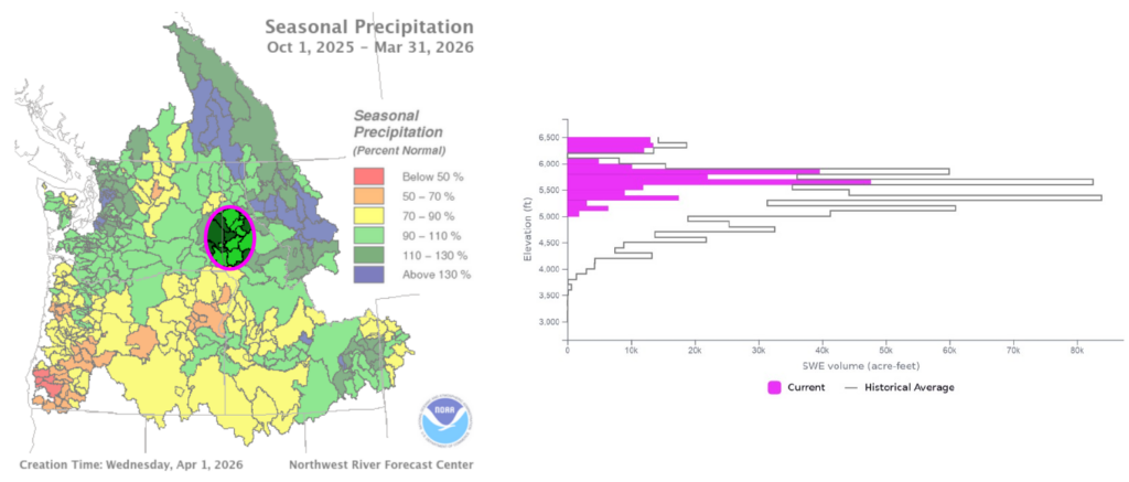
Figure 5a (left) – Northwest River Forecast Center seasonal precipitation as a percent of normal, the magenta circle outlines the approximate location of the Dworshak basin. Figure 5b (right) – Snow water equivalent in the Dworshak basin on May 18, 2026. Source: HydroForecast.
To better anticipate these conditions, HydroForecast blends sub-seasonal predictions from global weather models, including NOAA’s GEFS and ECMWF, with decades of historical weather data. This helps the model distinguish between precipitation falling as rain or snow, anticipate snowpack development, and forecast how today’s weather will influence basin flows months into the future
Managing extremes: Four lessons for water operators
The 2026 Water Year in the PNW demonstrated how quickly conditions can swing between flood and drought, setting records and challenging water managers along the way. With a potentially historic El Niño developing in the Pacific, the 2027 Water Year could bring another warm, low-snow winter to the region. These extremes may present different operational challenges, but they share a common need: reliable forecasts that help operators make decisions under uncertainty.
Based on our experience forecasting these events, here are four practical takeaways for operators navigating rapidly changing conditions:
- Build more lead time into flood preparedness. When high flows are approaching, every additional day matters. Use early warnings to evaluate reservoir drawdowns, notify staff and downstream communities, and prepare critical infrastructure before floodwaters arrive. More lead time gives operators greater flexibility to act before conditions become urgent.
- Prepare for a range of outcomes, not just a single forecast. During extreme events, uncertainty can be significant. Probabilistic forecasts help operators understand the range of possible flows and develop response plans for low, moderate, and high scenarios. Preparing for a variety of plans in advance makes it easier to act confidently under pressure and adjust operations as forecasts evolve.
- Look beyond precipitation totals to anticipate water shortages. A wet winter doesn’t necessarily translate into a healthy snowpack or sufficient spring runoff. During the 2026 Water Year, sub-seasonal forecasts indicated that warm conditions would limit snow accumulation despite average precipitation. Also accounting for temperature and antecedent conditions into streamflow forecasts can help operators anticipate water shortages and make proactive decisions about reservoir storage.
- Prepare for the next extreme while managing the current one. In the PNW, forecasting the 2026 drought began during the winter floods. Even as operators responded to high flows, forecasts were pointing toward limited spring runoff and a return to drought conditions. Incorporating both short-term and seasonal forecasts into reservoir planning helps operators balance immediate flood risks with longer-term water supply needs.
No operator wants to prepare for a drought in the middle of a flood, but that’s increasingly the reality of managing water resources. Forecasts that extend from days to months ahead give operators the visibility to respond to today’s conditions without losing sight of what’s coming next.
Learn how HydroForecast can help your team anticipate changing conditions and make more informed water management decisions. Talk to our team →.

